Drones Becoming a Valuable Weed Control Tool
Something went wrong. Please try again later...
Unmanned aerial systems (UAS) that speed weed ID and field location scouting are blazing a new trail of weed control efficiency.
When teamed with astute agronomist/farmer decisions, acres sprayed can be cut by 30 to 50% or more. And in some cases, drone sprayers can efficiently spot spray weeds, insects and diseases.
Northeast Kansas-based Ag Partners Co-op has taken their scouting service for farmers to the next level using drone photos on more than 50,000 acres a year, plus using drones to spray a combined 6,000 acres over the last two years.
“We use drones for a couple purposes,” says Ethan Noll, Digital Ag Team Lead for Ag Partners, Hiawatha, Kansas. “We use Taranis to provide three sets of high-definition photos during the growing season to identify stand counts, weed species, insects, diseases, nutrient deficiencies and plant defoliation.”
The Taranis scouting tool can pinpoint the exact location of a pest, identifies its species and the severity level of the problem using artificial intelligence (AI), machine learning and computer vision. “Once an agronomist and farmer agree on the best solution by examining the photos on a phone app, we can load the shape file into the drone and it will spot spray only those problem areas in the field,” Noll says.
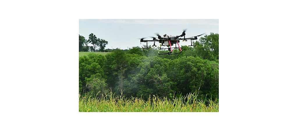
Rather than burn fuel and manhours on a whole-field postemergence spray, Ag Partners uses DJI T30 Rantizo sprayer drones that fly a 20-foot spray pattern six-feet above the crop. “For example, on my own 80-acre field, I had some grass escapes from my residual herbicide application. Using the photo to create a map, the drone sprayed 30 acres instead of 80, which is a big savings as glyphosate is $13 per acre and fuel is expensive. When I checked the third photo several weeks later, the drone achieved 100% weed control,” Noll adds.
North Dakota State University (NDSU) is four years into research examining the entire workflow from flying a drone to mapping weed distribution in the field and using that map to create a prescription that is then fed into a commercial size self-propelled sprayer to spray fields. “Regarding mapping, we’re seeing similar results to other researchers by achieving a 30% to 70% reduction in acres that need to be sprayed in a given field,” says Paulo Flores, NDSU Department of Agricultural and Biosystems Engineering assistant professor.
“One of the project’s goals is to determine the economic threshold by grid size, since we spray by grid,” he says. “For example, in 2022 we used 5x10-foot grids and we achieved a 50% savings in acres, only spraying grid cells that contained weeds. That would be a huge savings by spraying only 500 acres of a 1,000-acre farm.”
Current drone technology that limits spray tank size and battery life makes spraying large fields time consuming. Noll says their Rantizo drone sprayer can treat 17 to 20 acres per hour, given battery changes and spray tank refills.
Flores believes those limitations will slow adoption on larger fields, unless there are only a few weed patches that farmers could hire flown by a drone. In Kansas, Noll says, regardless, their drone spraying business is doubling every year. “Our farmer customers using drone spraying are excited about the efficiency and cost savings, especially with rising input prices,” he adds.
Along with spraying weed patches like volunteer corn and shattercane, Noll uses the drone for fungicide and insecticide application. “On high value crops like alfalfa — which are usually on smaller fields — farmers have us spray entire fields. Then they don’t have to clean out their self-propelled sprayer that is usually busy with corn and soybean fields,” he says.
Not only do the drone photos pinpoint spot spraying, they help create a useful data map for future planning. “Our farmer-customers and their agronomists now have exact weed ID and location photos from planting through tasseling to help address future herbicide plans,” he says. “We can also detect what weeds are entering fields from ditches and can spray the entry point to reduce future problems.”
Content provided by DTN/Progressive Farmer.
Find expert insights on agronomics, crop protection, farm operations and more.